Ukraine=Rus’ - a lesson in geography not learned


| Where did the Ukrainians come from? | |
|---|---|
|
Question: ”Where did the Ukrainians come from?” after the previous page, which
proves that Ukraine is Rus’ (Little Rus’ and Great Rus’ [1]~[2]~[3]~[4]), it sounds silly. As we may know, there are
no stupid questions, only stupid answers. Well, this page will consider the
geography of the ethnos of Rus’, in which we see modern Ukrainians, so that the
answer to this question will sprout by itself. The next map of 1237 incorporates various maps of that period and reflects the boundaries of various principalities and lands adjacent to other ethnic groups (striped zones). This map, like all others on this page, has Russian origin to avoid accusations of bias.  On this map, Moscow is a small town at the crossing of the river of the same name, for a safe stop on the road to Vladimir, the capital of the Vladimir-Suzdal principality. Moscow is the outskirts of this principality, and Kursk is in the middle of the Chernigov principality. Kozelets also belongs to the Chernigov principality (it is the Chernigov region in modern Ukraine) [5]. What miracle made Moscow, a town on the outskirts of the principality, a powerful capital? If the invasion of the Golden Horde brought Rus’ the yoke of tribute and death to its defenders, then for Moscow it became a finest hour. Moscow becomes the hub for collecting tribute in Rus’. From the middle of the 14th century, the monopoly of collecting taxes from all over Rus’ was given to Moscow. The Moscow princes kept 6-12% of the collected tribute, which made it possible to centralize Rus’ [6]. Moscow received not only the “power of money” but also the right to complain about the “rebellious”, sending punitive raids on them by the invaders. In the east of the Volodymyr-Suzdal principality, the lands where the population is merging with Finno-Ugric (Mordovia, Mariytsi, and Permyak) are marked with striped coloring. Such a merger will begin to change the Slavic language and culture. This process accelerated during the time of the Golden Horde when Moscow received the position of chief “overseer“ of Rus’ [6]. Moscow extends its borders to the east and encourages the settlement of these peoples in Moscow itself. The most likely reason for this is the use of Finno-Ugric peoples to collect taxes from Rus’. The profit from tax collection from Rus’ is such that Moscow was able to announce himself as a kingdom, having reformed the system of power [7]. In 1721, the Moscow kingdom of Peter the 1st became the Russian Empire, which continued to seize new lands [8], but did not repeat the mistakes of the Golden Horde. The Empire erases the historical memory of the annexed peoples in order to destroy national identity and resistance to muscovization (imposition of Moscow culture and language), having created the secret office of Peter the 1st in 1718 . For Ukraine, this began with the burning of the library of the Kiev Cave Lavra on the night of April 21-22, 1718 [9] and strengthening the fight against the Ukrainian language [10]. |
| The East of Kyivan Rus’ and the Muscovite Kingdom | |
|---|---|
|
Here we will consider how the east of Great Rus’ (the east of modern Ukraine) was
annexed. The Russian Empire is becoming a prison of nations. To prove it, we will
use evidence of the accused party against itself - ethnic maps of the Russian Empire.
There, we can see the dynamics of convergence over 50 years, comparing the two
the following maps of 1857 and 1907 [11]~[12]. The cities of Kursk,
Voronezh and Bilhorod on maps of 1907 have already been moved beyond the borders
of the Chernihiv principality, but still remain Ukrainian speakers
[16].
The empire is expanding in all directions, but most clearly on the given maps the muscovization (imposition of Moscow culture and language) of the Finno-Ugric and Turkic peoples in the east, which are fragmenting to pieces: 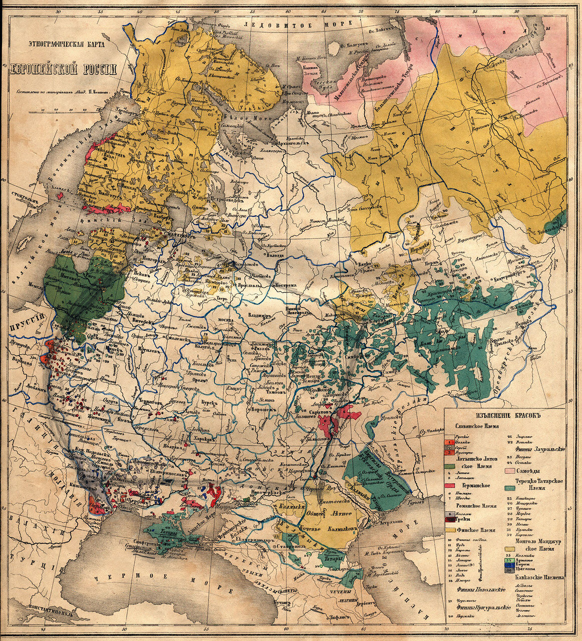 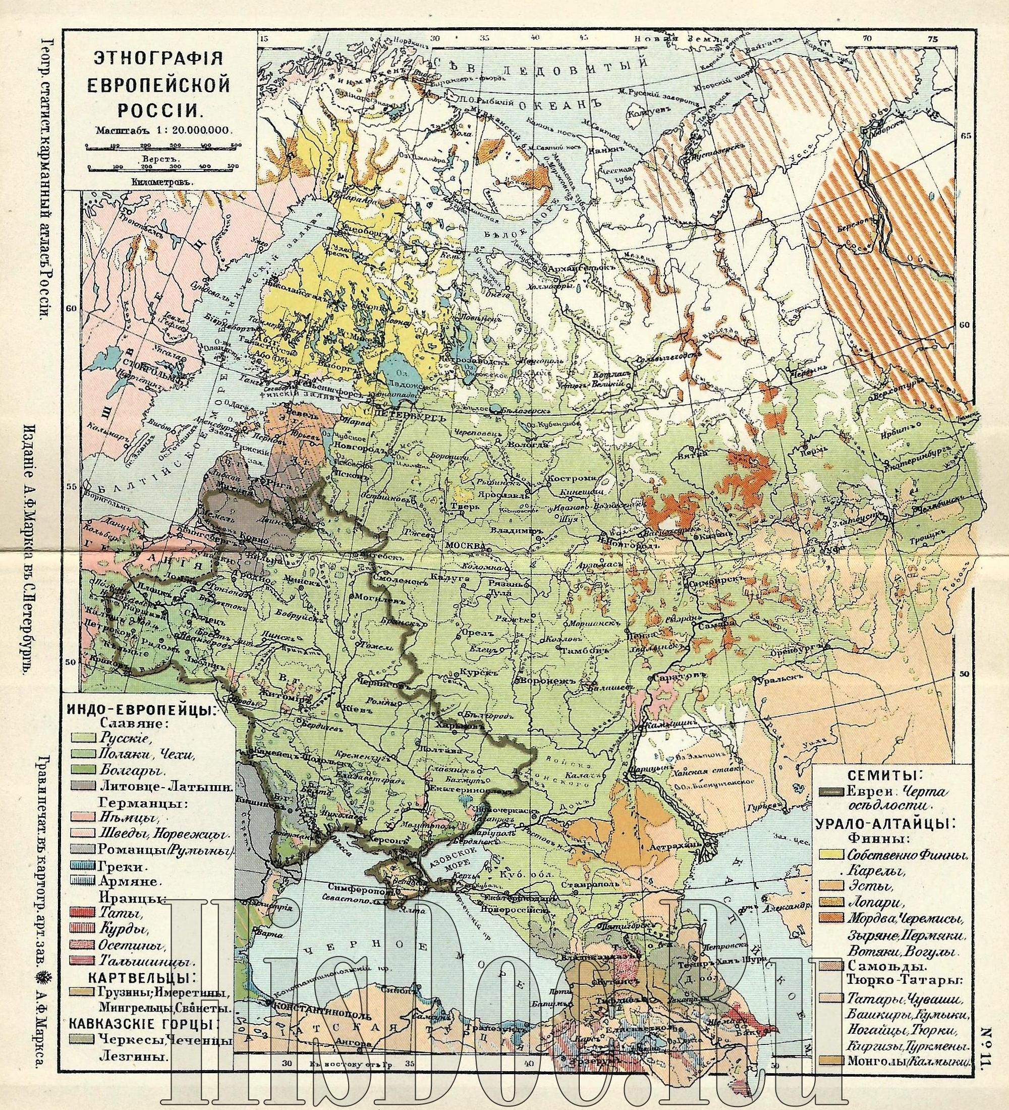 The maps of 1857 and 1907 show that the empire has done “good work“ in 50 years. When we compare the map of 1907 with the map of the Volodymyr-Suzdal principality, which gave birth to the Moscow kingdom, then its initial size is about 20% of the annexed lands with non-Slavic peoples [5]. The reverse influence of the annexed peoples on the culture of the Muscovite Empire formed a separate national cultural identity of the Muscovites. |
| Where did Ukrainians manage to preserve the culture of Kyivan Rus? | |
|---|---|
|
The following map shows the West of Kyivan Rus, where its culture and language
have undergone the least destruction by the Russian Empire. The Pale of
settlement (reservation) of Jews almost coincide with the lands where Ukrainians
are still resisting integration [15].
Which the motive of the empire in temporary weakening the convergence on these lands?
This “grey zone“ lies between the empire and its enemies in the West and South.
Moscow is forced to behave diplomatically so that the population of this zone
does not switch to the side of it enemies.
Less than a month passed after Crimea was declared Russian (April 8, 1783), how the empire ”repaid” Ukraine for the allied assistance in annexing Crimea. By decree of the Russian empress Catherine II of May 3, 1783, free peasants Left-bank Ukraine and Slobozhanshchyna were declared serfs [17]. Empire already dealt with the enemies and does not need the help of the Ukrainian Cossacks and shooters who hoped in vain for gratitude from the pseudo-empire. Having dealt with the enemies, the empire did not calm down, but became even more enraged. Just as Finno-Ugric (Mordva, Mari and Udmurt) became Slavs [5], the Balts (Lithuanians-Latvians) are also included among the Slavs. This can be seen from the fragment of the map below [15]: |
| Conclusions | |
|---|---|
|
Researching the topic “Ukraine=Rus’ - an unlearned geography lesson“, we came
across on an unexpected detail. First of all, the Ukrainians did not learn this
lesson. They are trying to find their place in history, inventing a non-existent
ethnic group of “Ukrains“. At the same time, they have no idea that they are
Kyivan Rus’ (Great and Little Rus’) [3], and the Moscow kingdom is their
former periphery (outskirts) [5],
which arose out of betrayal of Rus’ and conducts
hostile actions towards the descendants of Rus’ to this day.
Ukrainians grew up on textbooks that call Ukraine and Russia brotherly nations. Another view of history was and is a criminal offense in the Muscovite Empire, as no matter how this empire is called now. Let’s take a scientifically based look at it’s from a third part. | |
 | This book confirms our conclusions: “Brothers or Enemies: The Ukrainian
National Movement and Russia, from the 1840s to the 1870s by Johannes Remy, 2016
ISBN: 9781487511067“ (English) [18]. This is some help to the conclusions of our investigation, but it is a weapon against a narrow circle of imperial propagandists. Besides, they may know the truth as professional historians, but lie for money. They are not paid for the truth. The most difficult audience is people who do not want to know the truth. They do not want to destroy their vision of the world planted in their heads by the propaganda machine. |

Citations and references

| ||
|---|---|---|
| [1] | Source: | Ukraine - Lithuanian and Polish rule. Britannica (English) |
| [2] | Source: | The War in Ukraine - Ukraine before the First World War. University of Connecticut 1921 (English), USA. |
| * | Mirror: | Ukraine came under Polish-Lithuanian Commonwealth control. University of Connecticut 1921 (English), USA. |
| [3] | Source: | Origin of the concept of Little Russia. (Russian), Dmitry Sharko, 2019 Russia |
| * | Mirror: | Origin of names Little and Great Rus’ (Russian) Dmitry Sharko, 2019 Russia. |
| [4] | Source: | A general outline of the prairie plains commonly known as Ukraina: with the adjacent provinces by William de Beauplan 1648 (oriented with north to the bottom), US Library of Congress. |
| * | Mirror: | A general outline of the prairie plains commonly known as Ukraina: with the adjacent provinces by William de Beauplan 1648 (oriented with north to the bottom), US Library of Congress. |
| [5] | Source: | Principality of Kiev Map of principalities of Rus’ in 1237 |
| * | Mirror: | Map of principalities of Rus’ in 1237 from wikipedia |
| [6] | Source: | How the Moscow princes made money by collecting tribute for the Golden Horde (Russian) Alexander Kostyukhin “Forum Bell” 2017, Russia |
| * | Mirror: | How the Moscow princes made money by collecting tribute for the Golden Horde (English, translated from Russian) Alexander Kostyukhin “Forum Bell” 2017, Russia |
| [7] | Source: | Grand Principality of Moscow, Britannica |
| [8] | Source: | Peter the Great, World History Encyclopedia |
| [9] | Source: | The Legacy of Sts. Anthony and Theodosius: The Kiev Caves Lavra , Orthodox Christianity 2015 |
| [10] | Source: | A guide to the history of oppression of the Ukrainian language, by Olena Siruk 2022 |
| * | Mirror: | A guide to the history of oppression of the Ukrainian language, by Olena Siruk 2022 |
| [11] | Source: | Ethnographic map of European Russia, 1857 (Russian) |
| * | Mirror: | Ethnographic map of European Russia, 1857 (Russian) |
| [12] | Source: | Ethnographic map of the Russian Empire according to Ritikh and Venyukov St. Petersburg: Ilyin, 1862 |
| * | Mirror: | Ethnographic map of the Russian Empire according to Ritikh and Venyukov, St. Petersburg: Ilyin, 1862 |
| [13] | Source: | Ethnographic map of the Russian Empire, A. Ilyin, 1889 |
| * | Mirror: | Ethnographic map of the Russian Empire, A. Ilyin, 1889 |
| [14] | Source: | Ethnography of the Russian Empire, A.F. Marx, St. Petersburg, 1907 |
| * | Mirror: | Ethnography of the Russian Empire, A.F. Marx, St. Petersburg, 1907 |
| [15] | Source: | Ethnographic map of European Russia, 1907 A.F. Marks (St. Petersburg) |
| * | Mirror: | Ethnographic map of European Russia, 1907 A.F. Marks (St. Petersburg) |
| [16] | Source: | Belgorod is the capital of Soviet Ukraine by Gennady Efimenko, 2017 “This day in history“ (Ukrainian) |
| * | Mirror: | Belgorod is the capital of Soviet Ukraine by Gennady Efimenko, 2017 (English) |
| [17] | Source: | Enslavement of the peasants of the Ukrainian Left Bank and Slobozhanshchina, Radio Liberty, 2006 (Ukrainian) |
| * | Mirror: | Enslavement of the Ukrainian peasants by Russian Empress Catherine II, Radio Liberty, 2006 (English) |
| [18] | Source: | Brothers or Enemies: The Ukrainian National Movement and Russia, from the 1840s to the 1870s by Johannes Remy, 2016 ISBN: 9781487511067 |
*Mirror: The mirror archive contains the same document as a source had at the publication time with a copyright attribues. Some documents may disappear from the Internet public access during the information war. It is why the most important documents are copied to the mirror archive. | ||